Introduction and Executive Summary
Fluid mud can be characterised as a very soft, high-concentration sediment layer that can behave like fluid while sitting above a consolidated seabed. In navigation channels, ports, harbour basins, river mouths and dredged reaches, this layer can create a false-bottom effect when surveying with high-frequency multibeam. Soundings may detect the top of the mud, even though the vessel may still be able to navigate through part of that layer. The operational question is therefore not simply “where is the first acoustic return?” but “where is the safe navigable bottom, and how much soft material lies above it?”
This challenge matters to port authorities, hydrographic offices, dredging contractors, pilots, harbour masters and waterway managers. Reliable identification of both the water-fluid mud interface and the underlying consolidated bottom supports safer navigation, better channel maintenance decisions, more targeted dredging, and improved confidence in clearance management. Historically, that information has required a combination of single-point, 2D profiling data measuring systems such as dual-frequency single beam echo sounders, sub-bottom profilers, density probes and manual interpretation. These methods can provide useful profiles but often leave large areas that are interpolated rather than directly measured.
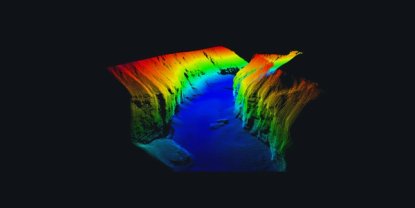
Since 2023 NORBIT has pioneered its original method called Layered Media Detection (LMD) which was first successfully demonstrated in 2023 during trials on the Calcasieu River (Lake Charles, Louisiana) in collaboration with the U.S. Army Corps of Engineers (USACE), New Orleans District. These early trials marked a breakthrough moment, demonstrating for the first time that a multibeam system could reliably “see” through fluid mud and resolve both the upper sediment layer and the underlying navigable bottom in a single pass.
Since that initial proof of concept, LMD has undergone rapid validation and refinement through an expanding series of field deployments across a wide range of environments. These include dynamic river systems, heavily trafficked navigation channels, and major international ports. Trials and operational demonstrations have been conducted throughout North America, Europe, South America, and beyond, including locations such as the Savannah River (USA) and multiple major Texas ports.
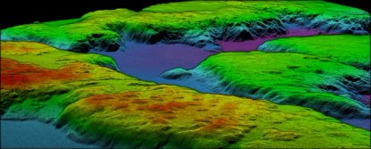
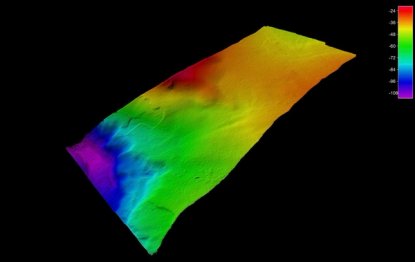
Results from these deployments have been consistent and repeatable. For example, validation work in Savannah, Georgia (2024) demonstrated clear separation between the high-frequency band surface representing the top of the fluid mud layer and the low-frequency band surface revealing the true bottom, including buried dredge features. Fluid mud penetration exceeding 12 feet was observed and confirmed across multiple independent survey areas.
![Savannah, GA validation example: the high-frequency band surface on the left and low-frequency band surface on the right use the same depth scale [ft], illustrating the difference between the upper layer and lower bottom.](https://cdn.sanity.io/images/7xbh1ny1/production/8a263e83e4146296df92c3b6f76fa39bb54a1015-672x262.png?w=672&q=85&fit=max&auto=format)
These examples reinforce the broader applicability of LMD in harbours, ports, rivers, turning basins and dredged navigation channels. Performance will still depend on site conditions, sediment properties, water depth, sonar configuration and required navigation criteria, but the field evidence shows that broadband multibeam layer detection can provide a practical path from line-based fluid mud assessment to full-coverage 3D mapping.
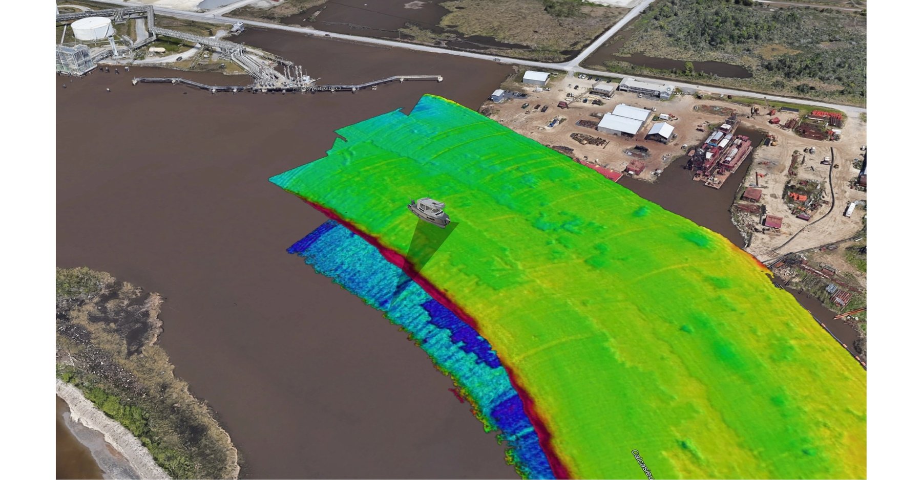
The following case study presents the next step in NORBIT’s LMD advances using the WINGHEAD X Midwater multibeam sonar system in collaboration with the U.S. Army Corps of Engineers (USACE), New Orleans District. The Calcasieu River survey demonstrates how LMD can acquire co-registered high-frequency and low-frequency band acoustic information in one pass, enabling full-coverage mapping of the top of soft sediment and the deeper navigable bottom
Project Background
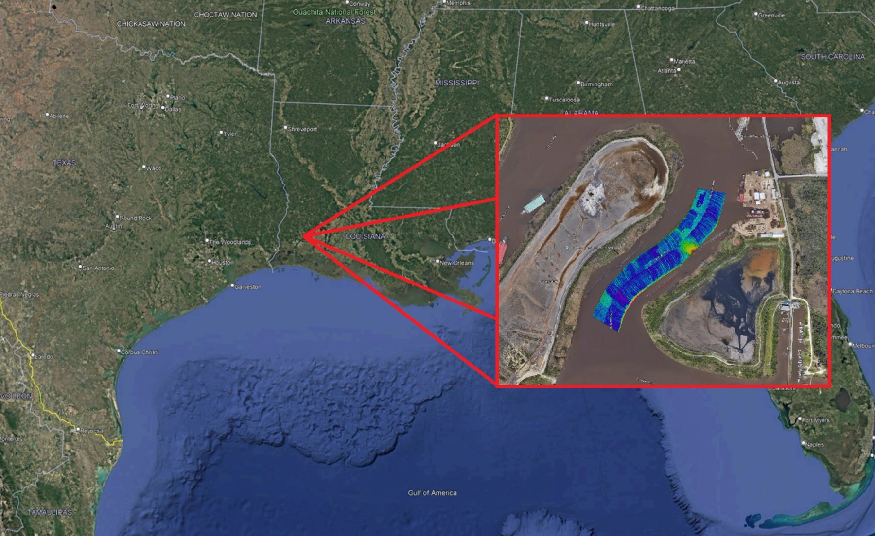
The survey was conducted on the
Calcasieu River near Clooney Island, Louisiana, an active dredging and navigation environment where soft sediment and recently disturbed material can move quickly. The area was selected because it represented a realistic operational problem:
- Recently dredged seabed conditions exhibiting sediment movement after dredging operations
- Significant fluid mud presence, including layers on the order of 1-2 m / 3-6 ft in the area
- A requirement to distinguish soft surface mud from the deeper consolidated bottom is used as a reference for navigation and clearance decisions
Traditional practice in this type of environment has commonly relied on dual-frequency SBES. A high-frequency band channel, typically 200 kHz, is used to detect the top of mud or lutocline, while a low-frequency band channel, typically 24-28 kHz, is used to identify the deeper navigable bottom. This method is well understood, but it suffers from limited single-point coverage. Surveyors must acquire separate profiles and then interpolate between them, which limits spatial confidence and can miss local sediment features, even objects or targets between survey lines.
The objective of the Clooney Island trial was to evaluate NORBIT LMD in a representative fluid mud environment for advantages over the traditional workflow by simultaneously acquiring both acoustic layers with full multibeam sonar coverage. Instead of generating isolated cross-sections, the aim was to produce continuous surfaces for the upper mud layer, the lower bottom, and the thickness difference between them.
Technology Overview
NORBIT LMD is a multibeam sonar method that uses broadband frequency-modulated signals and concurrent dual-band processing to separate acoustic returns from layered media. The high-frequency content is used to detect the water-fluid mud interface, or lutocline. The lower-frequency content is processed to penetrate through softer material and detect the lower acoustic bottom. In practical terms, the system outputs two co-registered data streams from the same survey pass: one representing the soft sediment surface and one representing the deeper navigable bottom.
- High-frequency band detections identify the top of suspended sediment or fluid mud with high spatial resolution
- Low-frequency band detections penetrate suspended material to detect the lower consolidated or acoustic basement layer
- Co-registration: both datasets are collected in the same pass and referenced to the same positioning and motion solution
- Operational outputs: top-of-mud surface, navigable-bottom surface, mud-thickness/difference surface, and volume estimates
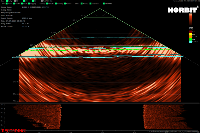
The LMD method is designed to avoid the common “alternating bottom” problem seen in conventional sonar data collected over fluid mud, where some detections return from the upper soft layer while others return from the lower bottom. By treating the two layers as separate acoustic targets, LMD provides surfaces that can be interpreted independently rather than as a single mixed and ambiguous bottom.
System Configuration and Mobilisation
The field configuration used a NORBIT WINGHEAD X Midwater multibeam sonar system with the LMD feature enabled and integrated GNSS/INS positioning. The compact size of the system supports both temporary mobilisation on survey poles and more permanent vessel installations like hull mounts. For short-duration trials or customer demonstrations, the same general package can be deployed as a survey-ready kit using NORBIT sonar hardware, GNSS/INS, acquisition software, cabling, and a portable mounting solution such as the PORTUS pole system.
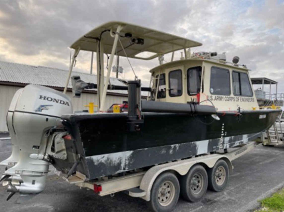
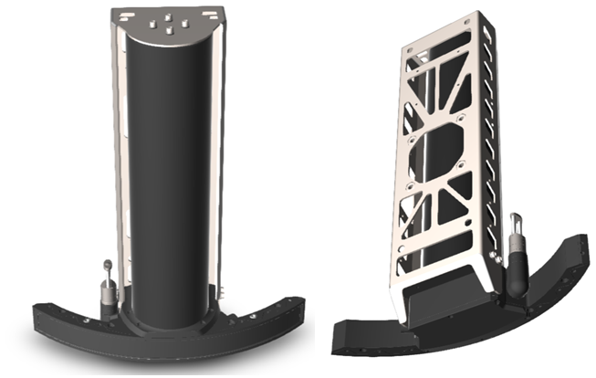
For high-availability survey vessels, LMD can also be incorporated into a more permanent hull-mounted configuration. Hydrodynamic fairing reduces exposure and supports efficient transit between survey areas, while preserving the ability to acquire multibeam and layered-media data during dedicated survey operations.

Data Acquisition
The survey was performed with LMD enabled so that both layers were collected in a single multibeam pass. The configuration produced wide-swath coverage across the channel area, full multibeam sounding density, and simultaneous acquisition of the upper and lower acoustic layers. Compared with the traditional SBES workflow, this greatly reduces the number of survey passes and replaces interpolation between sparse profiles with direct area coverage.
- Wide swath coverage for channel and river work
- Dense multibeam coverage across the survey area rather than measurements only along track lines
- Simultaneous acquisition of high-frequency band and low-frequency band returns
- Independent surfaces for the top of suspended sediment and the lower bottom
- Compatibility with standard hydrographic workflows and third-party acquisition/processing environments
Because the two layers are collected at the same time, the resulting surfaces are less affected by the temporal change between passes. This is particularly important in fluid mud environments, where tides, river flow, dredging discharge and vessel traffic can rapidly redistribute suspended and recently deposited sediment.
Results
Full Coverage Through Fluid Mud
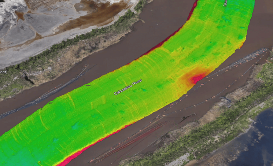
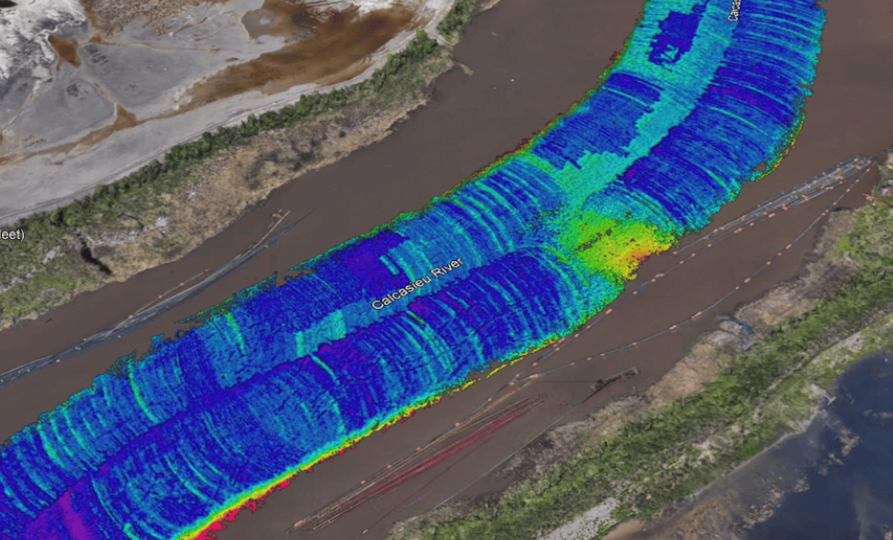
The LMD system successfully mapped through approximately 1-2 m / 3-6 ft of fluid mud in the Clooney Island area and produced continuous coverage of the underlying bottom. This is a key operational improvement over line-based SBES surveys, where the space between lines is inferred rather than directly measured. The result is not only a depth profile, but an area-based model of where the soft layer sits relative to the deeper navigable bottom.
Clear Separation of Layers
A major operational benefit of LMD is its ability to separate the apparent top of soft sediment from the deeper navigable bottom across the full survey area. In an active dredging environment like Clooney Island, this makes it easier to identify where soft material is accumulating, where the underlying dredge bottom remains visible, and where dredging or follow-up investigation should be prioritised.
- The dataset clearly distinguishes the top of the mud or soft-sediment layer from the lower navigable bottom surface.
- This separation turns sediment thickness into a spatial surface and volume-management problem, rather than relying only on isolated line comparisons or interpolated profiles.
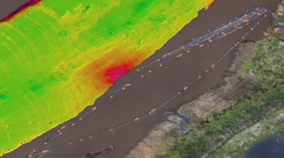
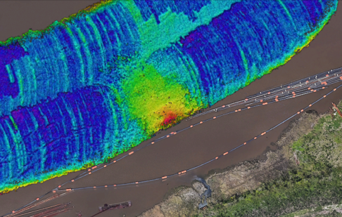
- In the Clooney Island imagery, the high-frequency band surface captures the shallower soft-sediment interface, while the low-frequency band surface penetrates through the softer material to reveal the deeper bottom morphology used for navigation and clearance decisions.
- Strong divergence between the two surfaces in areas of thicker, soft sediment, weaker consolidation, or recent deposition near the outflow region.
- Improved identification of zones where sediment accumulation may affect channel maintenance priorities or require additional verification.
By visualising both the apparent sediment surface and the deeper bottom morphology simultaneously, LMD supports more informed dredging and maintenance decisions. Areas where the lower surface already satisfies navigational clearance requirements may be differentiated from locations where accumulated sediment is operationally significant, helping reduce unnecessary dredging while focusing effort where it is most needed.
Agreement with Industry Standards
An important goal of the validation was to confirm that LMD derived surface matched the standard single-beam echo sounder, or SBES, methods used by USACE. In the Calcasieu cross-section, the LMD high-frequency band data match the 200 kHz SBES result, which is used to identify the top of the mud or soft sediment layer. The LMD low-frequency band data is consistent with the 24 kHz SBES result, which is used to identify the deeper navigable bottom. Minor localised offsets between the surfaces are expected because the multibeam datasets have several orders of magnitude more soundings, allowing for proper statistical operations and much smaller sounding footprints, resulting in significantly higher spatial resolution than the wider SBES beam footprints, allowing the multibeam to resolve finer-scale seabed variability.
This comparison supports both parts of the LMD workflow. The high-frequency band layer agrees with the accepted method for finding the top of the mud, and the low-frequency band layer agrees with the accepted method for finding the lower navigable bottom.
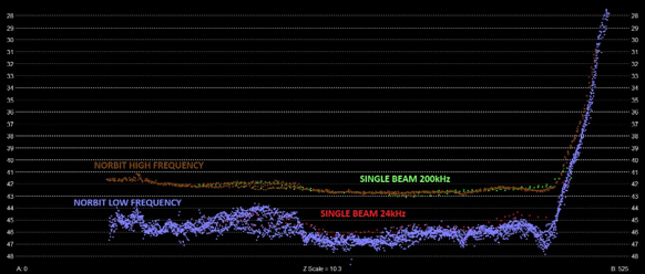
The implication is significant: LMD delivers results comparable to accepted SBES methods while adding full swath coverage. Instead of accepting sparse profiles as the primary evidence and interpolating between them, the survey team can create continuous top-layer, bottom-layer and difference surfaces across the area of interest.
New Insights into Sediment Dynamics
The trial also showed how full-coverage layered data can reveal sediment dynamics that would be difficult to diagnose from single-beam lines alone. Near discharge and outflow features, the surfaces show sediment redistribution and changes in consolidation across the dredged area. The relationship between the upper and lower layers helps distinguish where soft material has accumulated, where the underlying dredged morphology remains visible, and where the sediment column varies laterally.
This matters for maintenance dredging because a single depth number does not describe whether material is newly deposited, mobile, weakly consolidated, or part of the lower bed. With LMD, operators can compare top-of-mud and bottom surfaces directly, estimate mud thickness, and prioritise investigation or dredging in zones where material thickness or consolidation patterns are operationally relevant. This also allows temporal modelling of areas to support prediction modelling and future analysis.
Comparison with Traditional Workflows
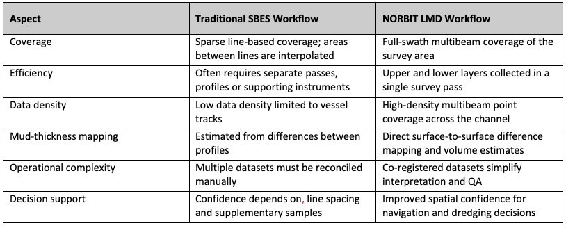
The Louisiana trial demonstrates that LMD can replace multiple survey steps, reduce field time by collecting both layers in one pass, and deliver more complete datasets for decision-making. Physical sampling or density profiling can still be valuable for ground truth, especially where a specific nautical-bottom density threshold is required, but LMD provides the area-wide acoustic framework that traditional point or line methods lack.
Operational Value
Dredging Operations
- Improves determination of navigable depth by separating the apparent top of mud from the perceived navigable bottom.
- Supports dredging progress monitoring by mapping how much soft material remains above the deeper surface.
- Reduces unnecessary dredging risk by showing where material may be navigable or where intervention is genuinely required. Isolation of these concentrated “thick” areas can be used for targeted dredging actions and to help mitigate to point of consolidation from radiating.
Hydrographic Surveying
- Provides full coverage in complex soft-sediment environments where single-frequency sonar can produce ambiguous returns.
- Improves confidence by producing co-registered high-frequency band and low-frequency band datasets rather than separate time-offset surveys.
- Reduces survey time due to wider coverage that collects the information that traditionally requires multiple passes or systems.
- Improves CATZOC ratability of channels and waterways with full ensonification now available
Port and Waterway Management
- Improves understanding of sediment dynamics, including deposition, redistribution and consolidation patterns.
- Supports maintenance planning by turning fluid mud from a line-profile problem into a surface and volume-management problem.
- Creates a more defensible basis for communication among surveyors, dredging teams, pilots, regulators and asset owners.
- Mitigates delays and penalties associated with draft restrictions.
Case Study Conclusion
The Clooney Island trial demonstrates the practical value of Layered Media Detection (LMD) in a challenging fluid mud environment. In a single multibeam survey, the system successfully separated and mapped both the apparent seabed (top of soft sediment) and the deeper navigable bottom as co-registered surfaces. The survey penetrated approximately 1–2 m (3–6 ft) of fluid mud while maintaining continuous bottom detection across the full area, providing a level of spatial completeness not achievable with traditional methods.
The results showed strong agreement with conventional dual-frequency single beam echo sounder (SBES) workflows, with the high-frequency band data corresponding to the top-of-mud surface and the low-frequency band data resolving the navigable bottom. Unlike sparse, line-based surveys that rely on interpolation, LMD delivered full-coverage data, enabling a more complete and spatially consistent understanding of sediment thickness and distribution.
In practical terms, the trial demonstrates that LMD can:
- Separate and map both the apparent seabed and the true navigable bottom in a single survey
- Penetrate fluid mud while maintaining continuous, full-coverage bottom detection
- Deliver results consistent with established SBES methods for both top-of-mud and navigable depth, with significant time savings
- Provide full-coverage insight into sediment thickness, variability, and movement patterns
- Visibility to sub-surface conditions for real-time adaptation of processes
This full-coverage approach improves confidence in navigational depth determination while reducing operational complexity and delivering more actionable information for dredging operations and waterway management.

Industry Adoption and Deployment
The NORBIT WINGHEAD X Midwater multibeam sonar system with Layered Media Detection represents a significant advancement in surveying suspended sediment and fluid mud environments. By combining full multibeam coverage with simultaneous dual-layer detection, LMD enables users to measure more accurately, interpret seabed conditions more clearly, and make faster, more informed operational decisions.
Since its initial validation in 2023, LMD has evolved from a proof-of-concept into a globally tested and field-proven technology. Successful deployments across rivers, ports, and navigation channels worldwide have demonstrated consistent performance in a wide range of sediment conditions, confirming its reliability as an operational solution rather than an experimental approach.
The underlying hardware platform is now fully mature and based on established NORBIT multibeam systems already in widespread use. This allows LMD to be integrated directly into existing survey workflows without the need for specialised equipment, lowering barriers to adoption, and enabling immediate operational use.
As adoption has expanded, users are beginning to explore new and often unexpected applications of layered multibeam data. Beyond navigational depth assessment, LMD is being applied to sediment transport analysis, dredging optimisation, change detection, and broader operational decision support in dynamic environments. These emerging use cases highlight that the value of the technology is increasingly driven by how operators choose to apply it in practice.
Looking ahead, the continued impact of LMD will depend less on technical capability and more on how effectively this new type of layered data is integrated into workflows and decision-making processes. NORBIT continues to support this transition through collaboration, training, software integration, and ensuring that users can fully realise the benefits of full-coverage, dual-layer seabed mapping. Through continued innovation and close collaboration with end users worldwide, NORBIT is not only advancing Layered Media Detection technology, but also establishing itself as a global leader in the future development of multibeam-based seabed and sediment characterisation.
References
- P. Pocwiardowski, Hydro International, Issue 1, 2024, Volume 28, “Mapping through fluid mud”, https://www.hydro-international.com/case-study/mapping-through-fluid-mud
- M. Mutschler, WEDA Pacific Chapter 2025, “Layered Media Detection”,
https://www.westerndredging.org/phocadownload/02-weda-2025-pacific.pdf - U. Bull, Proceedings of the 11th Workshop “Seabed Acoustics”, Innomar, “Layered Media Detection — A novel approach to efficient mapping in areas with fluid mud”
- On-line materials, https://www.youtube.com/watch?v=6vbKyWUoko4
- On-line materials, https://norbit.com/case-study/mapping-through-fluid-mud-with-norbit-winghead-sonar
- Present Practice of Using Nautical Depth to Manage Navigation Channels in the Presence of Fluid Mud, Timothy L. Welp and Michael W. Tubman, ERDC/TN DOER-D19 May 2017
- Alex Kirichek, et. al., How Navigable Are Fluid Mud Layers?, PIANC-World Congress Panama City, Panama 2018
- E. Reincke, Determination of the Nautical Depth, A literature review, Ministerie van Verkeer en Waterstaat, Directoraat-Generaal Rijkswaterstaat